
Magnitude |
3.6 |
| Date & Time (UTC) | 2025-11-30 11:39:20.6 |
| Date & Time (Local) | 1404/9/9 15:09:20.6 |
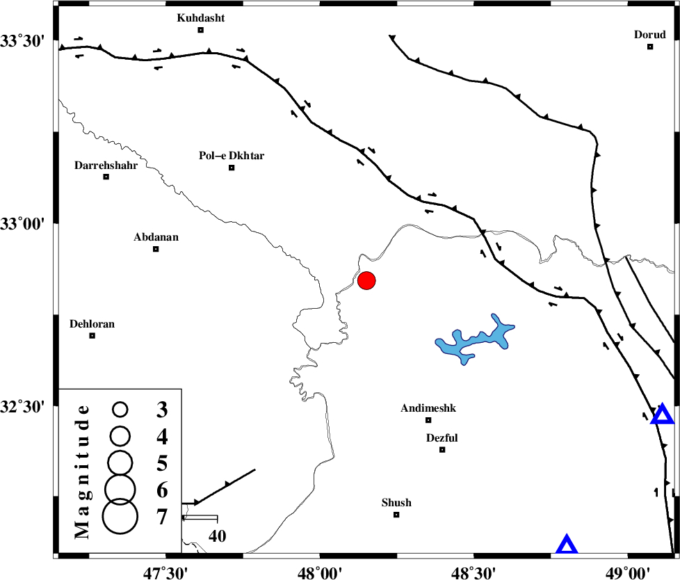
| Location | Lat:32.843 Lon: 48.151 |
| Region | Khoozestan Province, 47 km North-West of Andimeshk |
Nearest Cities |
|
| 13 km North of Bidruyeh, Khoozestan Province | |
| 18 km North West of Sorkhakan, Khoozestan Province | |
| 20 km North of Hoseinieh, Khoozestan Province | |
| 47 km North West of Andimeshk, Khoozestan Province | |
| 52 km South East of Sarab hammam, Lorestan Province | |
| Depth | 14 km |
| Agency | |
Faults within 150 km: |
|
| BALARUD_F_Z3 (Length: 53 km) , Distance to epicenter: 6 km | |
| BALARUD_F_Z1 (Length: 87 km) , Distance to epicenter: 11 km | |
| BALARUD_F_Z2 (Length: 58 km) , Distance to epicenter: 18 km | |
| Number of Phases | 10 |
| RMS | 0.4 |
| Number of Stations | 10 |
| Error in Latitude | 2.9 km |
| Error in Longitude | 2.9 km |
| Error in Depth | 567.8 km |
Download waveform in seisan format
to download seisan software Click here
to access information about IIEES stations Click here
Amplitude
| UID | Agency | Station | Component | Amplitude | Period | Arrival Time | Proccessing Time | Signal Clip |
|---|---|---|---|---|---|---|---|---|
| 200397 | IIEES SC | NASN | Z | 0.06 | 1 | 2025-11-30 11:40:23 | 2025-12-01 04:59:00 | n |
| 200398 | IIEES SC | SHRO | Z | 0.02 | 1 | 2025-11-30 11:41:08 | 2025-12-01 04:59:00 | n |
| 200399 | IIEES SC | TABS | Z | 0.01 | 1 | 2025-11-30 11:41:12 | 2025-12-01 04:59:00 | n |
Phase
| Agency | Station | Component | Phase Type | Phase Quality | Arrival Time | Time Residual | Loc. Flag | Input Weight | Distance | Azimuth |
|---|---|---|---|---|---|---|---|---|---|---|
| IIEES SC | BSR2 | Z | EPn | E | 2025-11-30 11:40:12 | 9 | n | 4 | 287 | 190 |
| IIEES SC | GHVR | Z | EPn | E | 2025-11-30 11:40:14 | 3.8 | n | 4 | 340 | 58 |
| IIEES SC | NASN | Z | EPn | E | 2025-11-30 11:40:23 | 0.9 | y | 0 | 436 | 91 |
| IIEES SC | CHTH | Z | EPn | E | 2025-11-30 11:40:25 | 2.2 | n | 4 | 436 | 39 |
| IIEES SC | YZKH | Z | EPn | E | 2025-11-30 11:40:44 | 0.1 | y | 0 | 607 | 95 |
| IIEES SC | GHIR | Z | EPn | E | 2025-11-30 11:40:53 | -0.2 | y | 0 | 686 | 137 |
| IIEES SC | SHRO | Z | EPn | E | 2025-11-30 11:41:08 | 0.3 | y | 0 | 804 | 64 |
| IIEES SC | TABS | Z | EPn | E | 2025-11-30 11:41:12 | -0.6 | y | 0 | 840 | 84 |
| IIEES SC | GNI | Z | EPn | E | 2025-11-30 11:41:15 | -0.2 | y | 0 | 866 | 339 |
| IIEES SC | EIL | Z | EPn | E | 2025-11-30 11:42:11 | 0.5 | y | 0 | 1306 | 254 |