
Magnitude |
3.3 |
| Date & Time (UTC) | 2025-12-03 00:20:25.4 |
| Date & Time (Local) | 1404/9/12 03:50:25.4 |
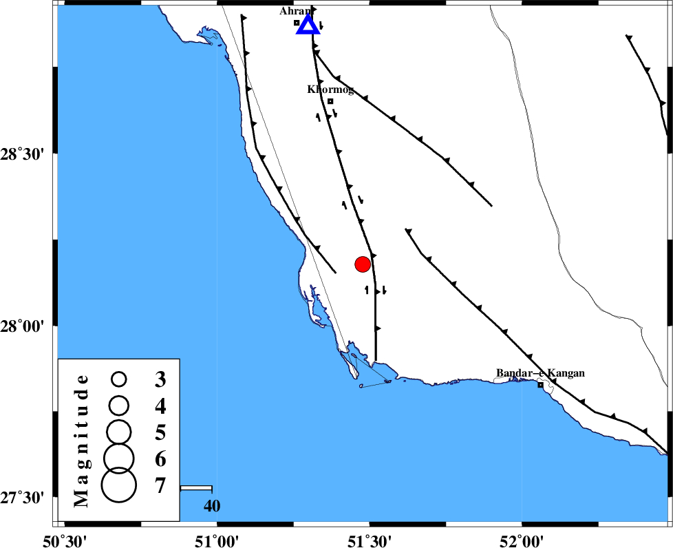
| Location | Lat:28.178 Lon: 51.477 |
| Region | Bushehr Province, 54 km South-East of Khormog |
Nearest Cities |
|
| 5 km North of Abkesh, Bushehr Province | |
| 11 km North East of Ziyarat, Bushehr Province | |
| 13 km North of Bardkhun, Bushehr Province | |
| 18 km South of Kaki, Bushehr Province | |
| 24 km South of Baduleh, Bushehr Province | |
| Depth | 12 km |
| Agency | |
Faults within 150 km: |
|
| BORAZJAN_F (Length: 168 km) , Distance to epicenter: 5 km | |
| ZFF2 (Length: 84 km) , Distance to epicenter: 9 km | |
| MFF3 (Length: 292 km) , Distance to epicenter: 18 km | |
| Number of Phases | 10 |
| RMS | 0.6 |
| Number of Stations | 10 |
| Error in Latitude | 4.3 km |
| Error in Longitude | 4.3 km |
| Error in Depth | 13.4 km |
Download waveform in seisan format
to download seisan software Click here
to access information about IIEES stations Click here
Amplitude
| UID | Agency | Station | Component | Amplitude | Period | Arrival Time | Proccessing Time | Signal Clip |
|---|---|---|---|---|---|---|---|---|
| 200419 | IIEES SC | NASN | Z | 0.02 | 1 | 2025-12-03 00:21:38 | 2025-12-03 07:45:00 | n |
| 200420 | IIEES SC | YZKH | Z | 0.06 | 1 | 2025-12-03 00:21:42 | 2025-12-03 07:45:00 | n |
| 200421 | IIEES SC | UOSS | Z | 0.02 | 1 | 2025-12-03 00:21:46 | 2025-12-03 07:45:00 | n |
| 200422 | IIEES SC | TABS | Z | 0.01 | 1 | 2025-12-03 00:22:13 | 2025-12-03 07:45:00 | n |
Phase
| Agency | Station | Component | Phase Type | Phase Quality | Arrival Time | Time Residual | Loc. Flag | Input Weight | Distance | Azimuth |
|---|---|---|---|---|---|---|---|---|---|---|
| IIEES SC | GHIR | Z | EPg | E | 2025-12-03 00:20:50 | 0.8 | y | 0 | 149 | 85 |
| IIEES SC | NASN | Z | EPn | E | 2025-12-03 00:21:38 | -0.3 | y | 0 | 528 | 14 |
| IIEES SC | YZKH | Z | EPn | E | 2025-12-03 00:21:42 | 0.5 | y | 0 | 555 | 33 |
| IIEES SC | UOSS | Z | EPn | E | 2025-12-03 00:21:46 | -0.2 | y | 0 | 592 | 127 |
| IIEES SC | TABS | Z | EPn | E | 2025-12-03 00:22:13 | -0.4 | y | 0 | 812 | 42 |
| IIEES SC | ZHSF | Z | EPn | E | 2025-12-03 00:22:27 | 0 | y | 0 | 920 | 80 |
| IIEES SC | IRSR | Z | EPn | E | 2025-12-03 00:22:29 | 0.1 | y | 0 | 936 | 98 |
| IIEES SC | CHBR | Z | EPn | E | 2025-12-03 00:22:28 | -1 | y | 0 | 939 | 108 |
| IIEES SC | SHRO | Z | EPn | E | 2025-12-03 00:22:32 | -0.9 | y | 0 | 968 | 26 |
| IIEES SC | SRSL | Z | EPn | E | 2025-12-03 00:22:45 | 0.9 | y | 0 | 1058 | 327 |