
Magnitude |
3.7 |
| Date & Time (UTC) | 2026-01-17 16:27:52.9 |
| Date & Time (Local) | 1404/10/27 19:57:52.9 |
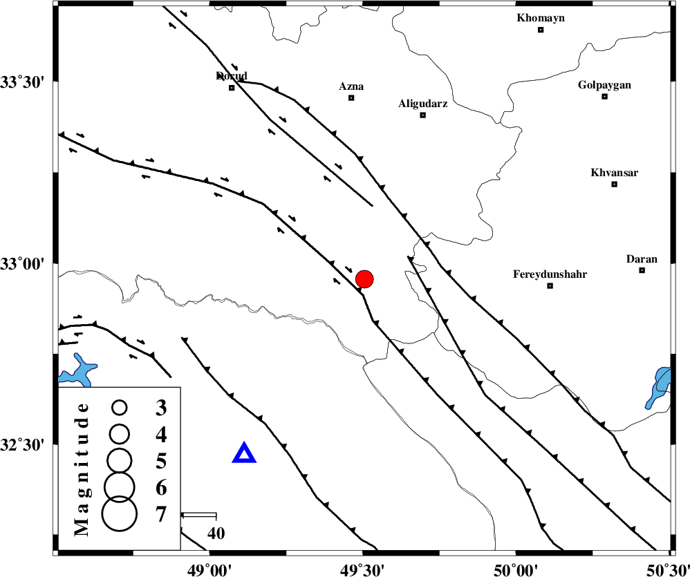
| Location | Lat:32.956 Lon: 49.505 |
| Region | Lorestan Province, 56 km South of Azna |
Nearest Cities |
|
| 6 km North of Parchal, Lorestan Province | |
| 35 km North West of Masir, Esfahan Province | |
| 37 km South West of Farsesh, Lorestan Province | |
| 38 km South West of Shapoorabad, Lorestan Province | |
| 38 km South West of Shapoorabad, Lorestan Province | |
| Depth | 12 km |
| Agency | |
Faults within 150 km: |
|
| HZF4 (Length: 492 km) , Distance to epicenter: 5 km | |
| ZARDKUH_F (Length: 139 km) , Distance to epicenter: 13 km | |
| ARDAL_F (Length: 170 km) , Distance to epicenter: 15 km | |
| Number of Phases | 7 |
| RMS | 0.5 |
| Number of Stations | 7 |
| Error in Latitude | 14.5 km |
| Error in Longitude | 14.5 km |
| Error in Depth | 85.5 km |
Download waveform in seisan format
to download seisan software Click here
to access information about IIEES stations Click here
Amplitude
| UID | Agency | Station | Component | Amplitude | Period | Arrival Time | Proccessing Time | Signal Clip |
|---|---|---|---|---|---|---|---|---|
| 201112 | IIEES SC | DOB | Z | 2 | 1 | 2026-01-17 16:28:17 | 2026-01-18 06:41:00 | n |
| 201113 | IIEES SC | HNVD | Z | 1 | 1 | 2026-01-17 16:28:24 | 2026-01-18 06:41:00 | n |
| 201114 | IIEES SC | KRVR | Z | 0.04 | 1 | 2026-01-17 16:29:28 | 2026-01-18 06:41:00 | n |
Phase
| Agency | Station | Component | Phase Type | Phase Quality | Arrival Time | Time Residual | Loc. Flag | Input Weight | Distance | Azimuth |
|---|---|---|---|---|---|---|---|---|---|---|
| IIEES SC | AMS1 | Z | EPg | E | 2026-01-17 16:28:10 | 0 | y | 0 | 102 | 187 |
| IIEES SC | DOB | Z | EPg | E | 2026-01-17 16:28:17 | -0.7 | y | 0 | 154 | 307 |
| IIEES SC | HNVD | Z | EPg | E | 2026-01-17 16:28:24 | 0.3 | y | 0 | 190 | 323 |
| IIEES SC | SFB | Z | EPn | E | 2026-01-17 16:28:38 | 0.6 | y | 0 | 297 | 59 |
| IIEES SC | KRVR | Z | EPn | E | 2026-01-17 16:29:28 | -0.5 | y | 0 | 708 | 102 |
| IIEES SC | KOO | Z | EPn | E | 2026-01-17 16:29:51 | -0.8 | y | 0 | 893 | 94 |
| IIEES SC | IRSR | Z | EPn | E | 2026-01-17 16:30:37 | -2.9 | n | 4 | 1281 | 121 |