
Magnitude |
3.1 |
| Date & Time (UTC) | 2025-07-29 02:00:54.7 |
| Date & Time (Local) | 1404/5/7 05:30:54.7 |
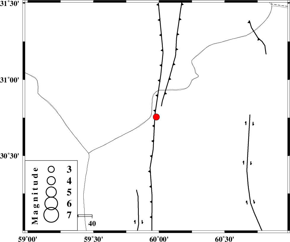
| Location | Lat:30.755 Lon: 59.979 |
| Region | Sistan va Baloochestan Province, 87 km South of Nehbandan |
Nearest Cities |
|
| 87 km South of Nehbandan, Khorasan(south) Province | |
| 102 km North of Nosratabad, Sistan va Baloochestan Province | |
| 124 km North West of Tasuki, Sistan va Baloochestan Province | |
| 136 km South of Shusef, Khorasan(south) Province | |
| 145 km South West of Adimi, Sistan va Baloochestan Province | |
| Depth | 12 km |
| Agency | |
Faults within 150 km: |
|
| W_NEH_F (Length: 158 km) , Distance to epicenter: 2 km | |
| E_NEH_F (Length: 148 km) , Distance to epicenter: 9 km | |
| KANURAK_F (Length: 135 km) , Distance to epicenter: 55 km | |
| Number of Phases | 8 |
| RMS | 0.6 |
| Number of Stations | 8 |
| Error in Latitude | 7.7 km |
| Error in Longitude | 7.7 km |
| Error in Depth | 999 km |
Download waveform in seisan format
to download seisan software Click here
to access information about IIEES stations Click here
Amplitude
| UID | Agency | Station | Component | Amplitude | Period | Arrival Time | Proccessing Time | Signal Clip |
|---|---|---|---|---|---|---|---|---|
| 199228 | IIEES SC | KRBR | Z | 0.3 | 1 | 2025-07-29 02:01:42 | 2025-09-20 10:18:00 | n |
| 199229 | IIEES SC | SHRT | Z | 0.07 | 1 | 2025-07-29 02:01:41 | 2025-09-20 10:18:00 | n |
| 199230 | IIEES SC | TABS | Z | 0.04 | 1 | 2025-07-29 02:01:55 | 2025-09-20 10:18:00 | n |
| 199231 | IIEES SC | KAGH | Z | 0.003 | 1 | 2025-07-29 02:02:27 | 2025-09-20 10:18:00 | n |
Phase
| Agency | Station | Component | Phase Type | Phase Quality | Arrival Time | Time Residual | Loc. Flag | Input Weight | Distance | Azimuth |
|---|---|---|---|---|---|---|---|---|---|---|
| IIEES SC | BSRN | Z | EPg | E | 2025-07-29 02:01:07 | -13.2 | n | 4 | 157 | 329 |
| IIEES SC | BSRN | Z | ESg | E | 2025-07-29 02:01:24 | -15.2 | n | 4 | 157 | 329 |
| IIEES SC | KRBR | Z | EPn | E | 2025-07-29 02:01:42 | -0.5 | y | 0 | 321 | 255 |
| IIEES SC | SHRT | Z | EPn | E | 2025-07-29 02:01:41 | -0.7 | y | 0 | 322 | 5 |
| IIEES SC | TABS | Z | EPn | E | 2025-07-29 02:01:55 | 0.8 | y | 0 | 419 | 320 |
| IIEES SC | IRSR | Z | EPn | E | 2025-07-29 02:01:56 | 0.2 | y | 0 | 428 | 168 |
| IIEES SC | YZKH | Z | EPn | E | 2025-07-29 02:02:01 | -8.3 | n | 4 | 543 | 290 |
| IIEES SC | KAGH | Z | EPn | E | 2025-07-29 02:02:27 | -0.3 | y | 0 | 686 | 360 |