
Magnitude |
3.4 |
| Date & Time (UTC) | 2025-07-28 20:19:29.2 |
| Date & Time (Local) | 1404/5/6 23:49:29.2 |
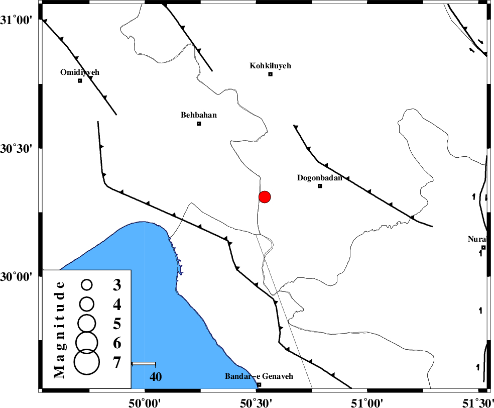
| Location | Lat:30.31 Lon: 50.538 |
| Region | Kohkiluieh va boyerahmad Province, 24 km -West of Dogonbadan |
Nearest Cities |
|
| 24 km West of Dogonbadan, Kohkiluieh va boyerahmad Province | |
| 30 km East of Sardasht, Khoozestan Province | |
| 34 km North East of Siyahmakan-e bozorg, Bushehr Province | |
| 37 km North East of Ameri, Bushehr Province | |
| 42 km South East of Mansuriyeh, Khoozestan Province | |
| Depth | 12 km |
| Agency | |
Faults within 150 km: |
|
| RAG_E_SEFID_F (Length: 84 km) , Distance to epicenter: 25 km | |
| ZFF3 (Length: 125 km) , Distance to epicenter: 25 km | |
| MISHAN_F (Length: 76 km) , Distance to epicenter: 28 km | |
| Number of Phases | 11 |
| RMS | 0.3 |
| Number of Stations | 11 |
| Error in Latitude | 2.1 km |
| Error in Longitude | 2.1 km |
| Error in Depth | 461.4 km |
Download waveform in seisan format
to download seisan software Click here
to access information about IIEES stations Click here
Amplitude
| UID | Agency | Station | Component | Amplitude | Period | Arrival Time | Proccessing Time | Signal Clip |
|---|---|---|---|---|---|---|---|---|
| 199264 | IIEES SC | GHVR | Z | 0.03 | 1 | 2025-07-28 20:20:35 | 2025-09-23 07:08:00 | n |
| 199265 | IIEES SC | SRSL | Z | 0.02 | 1 | 2025-07-28 20:21:17 | 2025-09-23 07:08:00 | n |
Phase
| Agency | Station | Component | Phase Type | Phase Quality | Arrival Time | Time Residual | Loc. Flag | Input Weight | Distance | Azimuth |
|---|---|---|---|---|---|---|---|---|---|---|
| IIEES SC | YZKH | Z | EPn | E | 2025-07-28 20:20:09 | -23.3 | n | 4 | 449 | 59 |
| IIEES SC | GHVR | Z | EPn | E | 2025-07-28 20:20:35 | 0.5 | y | 0 | 467 | 8 |
| IIEES SC | KRBR | Z | EPn | E | 2025-07-28 20:20:48 | -3.7 | n | 4 | 601 | 93 |
| IIEES SC | DAMV | Z | EPn | E | 2025-07-28 20:20:32 | -20 | n | 4 | 605 | 13 |
| IIEES SC | SRSL | Z | EPn | E | 2025-07-28 20:21:17 | -0.2 | y | 0 | 809 | 324 |
| IIEES SC | SHRO | Z | EPn | E | 2025-07-28 20:21:12 | -5.3 | n | 4 | 813 | 39 |
| IIEES SC | ABGH | Z | EPn | E | 2025-07-28 20:21:18 | -0.1 | y | 0 | 815 | 29 |
| IIEES SC | UOSS | Z | EPn | E | 2025-07-28 20:21:18 | -0.5 | y | 0 | 816 | 137 |
| IIEES SC | RAYN | Z | EPn | E | 2025-07-28 20:21:29 | 0.3 | y | 0 | 903 | 214 |
| IIEES SC | BJRD | Z | EPn | E | 2025-07-28 20:21:46 | 0.2 | y | 0 | 1037 | 38 |
| IIEES SC | IRSR | Z | EPn | E | 2025-07-28 20:21:50 | -0.1 | y | 0 | 1075 | 110 |