
Magnitude |
3.1 |
| Date & Time (UTC) | 2025-07-24 15:57:45.7 |
| Date & Time (Local) | 1404/5/2 19:27:45.7 |
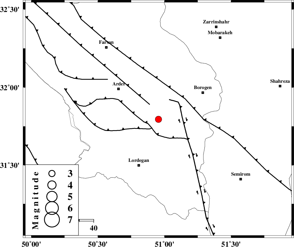
| Location | Lat:31.795 Lon: 50.955 |
| Region | Chaharmahal Bakhtiari Province, 36 km North-East of Lordegan |
Nearest Cities |
|
| 17 km South of Baladaji, Chaharmahal Bakhtiari Province | |
| 21 km West of Gandoman, Chaharmahal Bakhtiari Province | |
| 24 km North East of Armand-e olia, Chaharmahal Bakhtiari Province | |
| 26 km South East of Naghan, Chaharmahal Bakhtiari Province | |
| 29 km North West of Aluni, Chaharmahal Bakhtiari Province | |
| Depth | 12 km |
| Agency | |
Faults within 150 km: |
|
| SABZKUH_F (Length: 67 km) , Distance to epicenter: 8 km | |
| DOPOLAN_F (Length: 107 km) , Distance to epicenter: 8 km | |
| ARDAL_F (Length: 170 km) , Distance to epicenter: 12 km | |
| Number of Phases | 8 |
| RMS | 0.2 |
| Number of Stations | 8 |
| Error in Latitude | 1.1 km |
| Error in Longitude | 1.1 km |
| Error in Depth | 5.9 km |
Download waveform in seisan format
to download seisan software Click here
to access information about IIEES stations Click here
Amplitude
| UID | Agency | Station | Component | Amplitude | Period | Arrival Time | Proccessing Time | Signal Clip |
|---|---|---|---|---|---|---|---|---|
| 199312 | IIEES SC | NASN | Z | 0.2 | 1 | 2025-07-24 15:58:19 | 2025-09-27 07:28:00 | n |
| 199313 | IIEES SC | GHVR | Z | 0.2 | 1 | 2025-07-24 15:58:30 | 2025-09-27 07:28:00 | n |
| 199314 | IIEES SC | TABS | Z | 0.01 | 1 | 2025-07-24 15:59:10 | 2025-09-27 07:28:00 | n |
| 199315 | IIEES SC | SHRO | Z | 0.01 | 1 | 2025-07-24 15:59:16 | 2025-09-27 07:28:00 | n |
Phase
| Agency | Station | Component | Phase Type | Phase Quality | Arrival Time | Time Residual | Loc. Flag | Input Weight | Distance | Azimuth |
|---|---|---|---|---|---|---|---|---|---|---|
| IIEES SC | NASN | Z | EPn | E | 2025-07-24 15:58:19 | -0.2 | y | 0 | 207 | 57 |
| IIEES SC | GHVR | Z | EPn | E | 2025-07-24 15:58:30 | -0.1 | y | 0 | 299 | 5 |
| IIEES SC | GHIR | Z | EPn | E | 2025-07-24 15:58:47 | 0 | y | 0 | 436 | 153 |
| IIEES SC | DAMV | Z | EPn | E | 2025-07-24 15:58:39 | -8.2 | n | 4 | 436 | 12 |
| IIEES SC | TABS | Z | EPn | E | 2025-07-24 15:59:10 | 0.4 | y | 0 | 613 | 70 |
| IIEES SC | SHRO | Z | EPn | E | 2025-07-24 15:59:16 | 0.2 | y | 0 | 661 | 45 |
| IIEES SC | SRSL | Z | EPn | E | 2025-07-24 15:59:21 | 0 | y | 0 | 707 | 314 |
| IIEES SC | RAYN | Z | EPn | E | 2025-07-24 16:00:03 | -2.6 | n | 4 | 1063 | 210 |