
Magnitude |
3.1 |
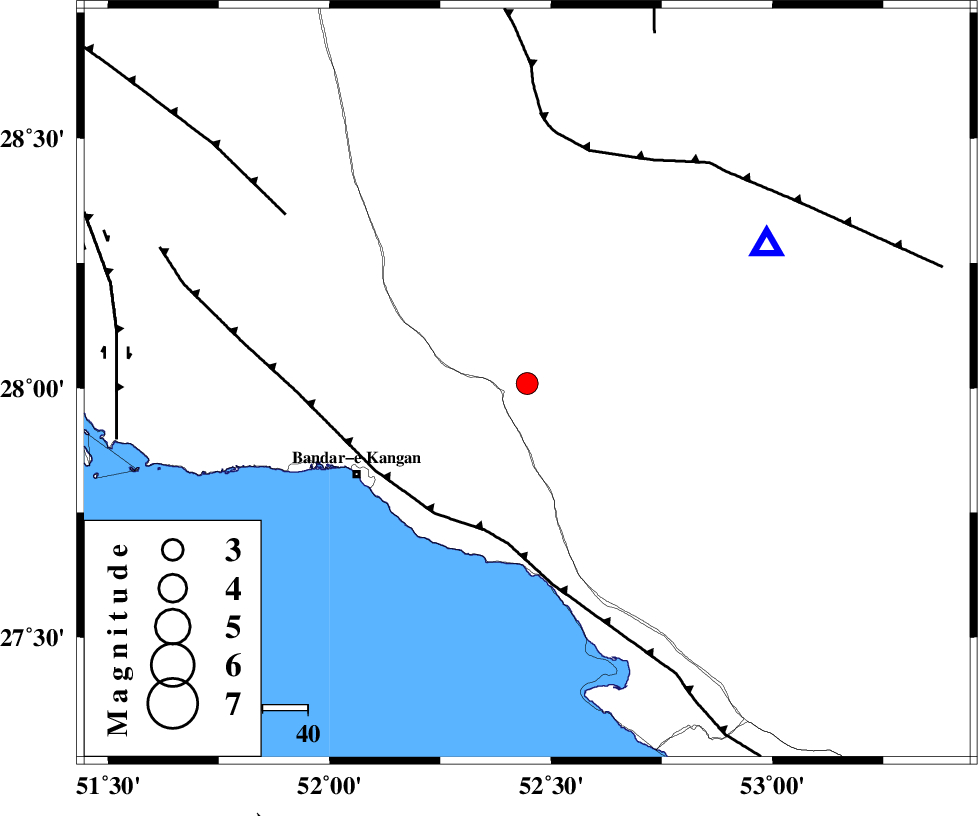
| Date & Time (UTC) | 2025-01-31 20:32:34.6 |
| Date & Time (Local) | 1403/11/13 00:02:34.6 |
| Location | Lat:28.009 Lon: 52.446 |
| Region | Fars Province, 23 km North-East of Jam |
Nearest Cities |
|
| 22 km South East of Dolatabad, Fars Province | |
| 23 km North East of Jam, Bushehr Province | |
| 28 km North West of Garmesht, Fars Province | |
| 37 km East of Riz, Bushehr Province | |
| 38 km North West of Asir, Fars Province | |
| Depth | 16 km |
| Agency | |
Faults within 150 km: |
|
| MFF3 (Length: 292 km) , Distance to epicenter: 34 km | |
| QIR_F (Length: 130 km) , Distance to epicenter: 54 km | |
| MFF5 (Length: 74 km) , Distance to epicenter: 65 km | |
| Number of Phases | 6 |
| RMS | 0.3 |
| Number of Stations | 6 |
| Error in Latitude | 2.5 km |
| Error in Longitude | 2.5 km |
| Error in Depth | 5.7 km |
Download waveform in seisan format
to download seisan software Click here
to access information about IIEES stations Click here
Amplitude
| UID | Agency | Station | Component | Amplitude | Period | Arrival Time | Proccessing Time | Signal Clip |
|---|---|---|---|---|---|---|---|---|
| 199629 | IIEES SC | YZKH | Z | 0.02 | 1 | 2025-01-31 20:33:47 | 2025-10-15 11:09:00 | n |
| 199630 | IIEES SC | NASN | Z | 0.02 | 1 | 2025-01-31 20:33:49 | 2025-10-15 11:09:00 | n |
| 199631 | IIEES SC | IRSR | Z | 0.006 | 1 | 2025-01-31 20:34:26 | 2025-10-15 11:09:00 | n |
Phase
| Agency | Station | Component | Phase Type | Phase Quality | Arrival Time | Time Residual | Loc. Flag | Input Weight | Distance | Azimuth |
|---|---|---|---|---|---|---|---|---|---|---|
| IIEES SC | GHIR | Z | EPg | E | 2025-01-31 20:32:45 | 0.2 | y | 0 | 61 | 60 |
| IIEES SC | YZKH | Z | EPn | E | 2025-01-31 20:33:47 | 0 | y | 0 | 528 | 23 |
| IIEES SC | NASN | Z | EPn | E | 2025-01-31 20:33:49 | 0.6 | y | 0 | 532 | 4 |
| IIEES SC | IRSR | Z | EPn | E | 2025-01-31 20:34:26 | -0.2 | y | 0 | 840 | 98 |
| IIEES SC | RAYN | Z | EPn | E | 2025-01-31 20:34:28 | 0.1 | y | 0 | 856 | 234 |
| IIEES SC | SRSL | Z | EPn | E | 2025-01-31 20:35:01 | -0.5 | y | 0 | 1125 | 324 |