
Magnitude |
3.3 |
| Date & Time (UTC) | 2025-01-07 23:12:29.8 |
| Date & Time (Local) | 1403/10/19 02:42:29.8 |
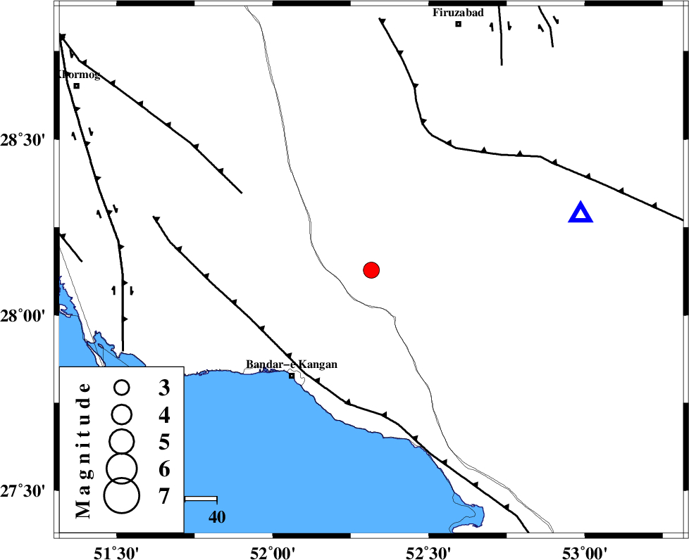
| Location | Lat:28.128 Lon: 52.316 |
| Region | Fars Province, 33 km North of Jam |
Nearest Cities |
|
| 3 km of Dolatabad, Fars Province | |
| 26 km North East of Riz, Bushehr Province | |
| 33 km North of Jam, Bushehr Province | |
| 40 km South of Dahrom, Fars Province | |
| 42 km North East of Bandar-e kangan, Bushehr Province | |
| Depth | 12 km |
| Agency | |
Faults within 150 km: |
|
| MFF3 (Length: 292 km) , Distance to epicenter: 39 km | |
| QIR_F (Length: 130 km) , Distance to epicenter: 47 km | |
| MFF5 (Length: 74 km) , Distance to epicenter: 47 km | |
| Number of Phases | 7 |
| RMS | 0.2 |
| Number of Stations | 7 |
| Error in Latitude | 2.4 km |
| Error in Longitude | 2.4 km |
| Error in Depth | 8.6 km |
Download waveform in seisan format
to download seisan software Click here
to access information about IIEES stations Click here
Amplitude
| UID | Agency | Station | Component | Amplitude | Period | Arrival Time | Proccessing Time | Signal Clip |
|---|---|---|---|---|---|---|---|---|
| 200123 | IIEES SC | UOSS | Z | 0.03 | 1 | 2025-01-07 23:13:42 | 2025-11-15 12:10:00 | n |
| 200124 | IIEES SC | TABS | Z | 0.009 | 1 | 2025-01-07 23:14:12 | 2025-11-15 12:10:00 | n |
Phase
| Agency | Station | Component | Phase Type | Phase Quality | Arrival Time | Time Residual | Loc. Flag | Input Weight | Distance | Azimuth |
|---|---|---|---|---|---|---|---|---|---|---|
| IIEES SC | GHIR | Z | EPg | E | 2025-01-07 23:12:41 | 0.1 | y | 0 | 68 | 75 |
| IIEES SC | KRBR | Z | EPn | E | 2025-01-07 23:13:40 | 3.1 | n | 4 | 479 | 65 |
| IIEES SC | UOSS | Z | EPn | E | 2025-01-07 23:13:42 | -0.3 | y | 0 | 524 | 132 |
| IIEES SC | TABS | Z | EPn | E | 2025-01-07 23:14:12 | 0 | y | 0 | 765 | 37 |
| IIEES SC | DAMV | Z | EPn | E | 2025-01-07 23:14:14 | -7.1 | n | 4 | 832 | 358 |
| IIEES SC | RAYN | Z | EPn | E | 2025-01-07 23:14:23 | 0.1 | y | 0 | 853 | 233 |
| IIEES SC | CHBR | Z | EPn | E | 2025-01-07 23:14:24 | 0.6 | y | 0 | 859 | 109 |