
Magnitude |
3 |
| Date & Time (UTC) | 2025-12-02 22:29:16.8 |
| Date & Time (Local) | 1404/9/12 01:59:16.8 |
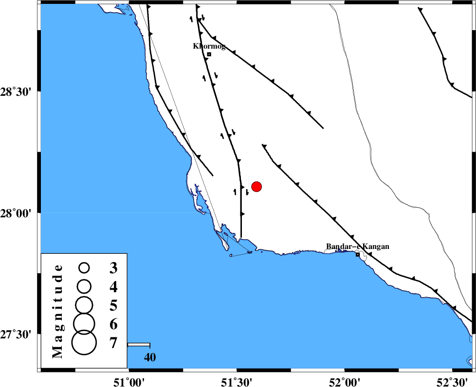
| Location | Lat:28.107 Lon: 51.591 |
| Region | Bushehr Province, 56 km North-West of Bandar-e kangan |
Nearest Cities |
|
| 9 km of Abkesh, Bushehr Province | |
| 13 km North East of Bardkhun, Bushehr Province | |
| 17 km North West of Abdan, Bushehr Province | |
| 23 km East of Ziyarat, Bushehr Province | |
| 27 km South of Kaki, Bushehr Province | |
| Depth | 12 km |
| Agency | |
Faults within 150 km: |
|
| BORAZJAN_F (Length: 168 km) , Distance to epicenter: 7 km | |
| MFF3 (Length: 292 km) , Distance to epicenter: 14 km | |
| ZFF2 (Length: 84 km) , Distance to epicenter: 20 km | |
| Number of Phases | 6 |
| RMS | 0.5 |
| Number of Stations | 6 |
| Error in Latitude | 14.7 km |
| Error in Longitude | 14.7 km |
| Error in Depth | 937 km |
Download waveform in seisan format
to download seisan software Click here
to access information about IIEES stations Click here
Amplitude
| UID | Agency | Station | Component | Amplitude | Period | Arrival Time | Proccessing Time | Signal Clip |
|---|---|---|---|---|---|---|---|---|
| 200417 | IIEES SC | NASN | Z | 0.01 | 1 | 2025-12-02 22:30:31 | 2025-12-03 07:27:00 | n |
| 200418 | IIEES SC | UOSS | Z | 0.02 | 1 | 2025-12-02 22:30:36 | 2025-12-03 07:27:00 | n |
Phase
| Agency | Station | Component | Phase Type | Phase Quality | Arrival Time | Time Residual | Loc. Flag | Input Weight | Distance | Azimuth |
|---|---|---|---|---|---|---|---|---|---|---|
| IIEES SC | GHIR | Z | EPg | E | 2025-12-02 22:29:41 | 2 | n | 4 | 138 | 82 |
| IIEES SC | NASN | Z | EPn | E | 2025-12-02 22:30:31 | 0.5 | y | 0 | 533 | 13 |
| IIEES SC | YZKH | Z | EPn | E | 2025-12-02 22:30:33 | -0.6 | y | 0 | 556 | 31 |
| IIEES SC | UOSS | Z | EPn | E | 2025-12-02 22:30:36 | -0.1 | y | 0 | 578 | 127 |
| IIEES SC | ZHSF | Z | EPn | E | 2025-12-02 22:31:17 | -0.2 | y | 0 | 911 | 79 |
| IIEES SC | IRSR | Z | EPn | E | 2025-12-02 22:31:20 | 0.6 | y | 0 | 924 | 98 |