
Magnitude |
3.1 |
| Date & Time (UTC) | 2026-01-17 14:07:43.6 |
| Date & Time (Local) | 1404/10/27 17:37:43.6 |
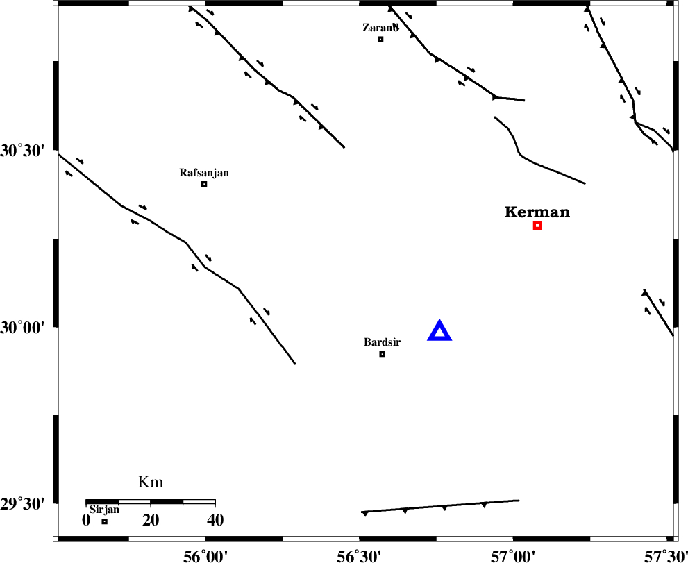
| Location | Lat:30.156 Lon: 56.521 |
| Region | Kerman Province, 26 km North of Bardsir |
Nearest Cities |
|
| 22 km South East of Kabutarkhan, Kerman Province | |
| 25 km North East of Mahutak, Kerman Province | |
| 26 km North of Bardsir, Kerman Province | |
| 29 km West of Baghin, Kerman Province | |
| 31 km North West of Dashtkar, Kerman Province | |
| Depth | 12 km |
| Agency | |
Faults within 150 km: |
|
| RAFSANJAN_F (Length: 129 km) , Distance to epicenter: 36 km | |
| DARIVAN_F (Length: 131 km) , Distance to epicenter: 39 km | |
| CHATRUD_F (Length: 37 km) , Distance to epicenter: 61 km | |
| Number of Phases | 6 |
| RMS | 0.8 |
| Number of Stations | 6 |
| Error in Latitude | 2.5 km |
| Error in Longitude | 2.5 km |
| Error in Depth | 15.5 km |
Download waveform in seisan format
to download seisan software Click here
to access information about IIEES stations Click here
Amplitude
| UID | Agency | Station | Component | Amplitude | Period | Arrival Time | Proccessing Time | Signal Clip |
|---|---|---|---|---|---|---|---|---|
| 201115 | IIEES SC | KRVR | Z | 0.2 | 1 | 2026-01-17 14:08:31 | 2026-01-18 07:06:00 | n |
| 201116 | IIEES SC | KRVR | Z | 0.2 | 1 | 2026-01-17 14:08:13 | 2026-01-18 07:06:00 | n |
| 201117 | IIEES SC | SRVN | Z | 0.009 | 1 | 2026-01-17 14:09:11 | 2026-01-18 07:06:00 | n |
| 201118 | IIEES SC | AMS1 | Z | 0.03 | 1 | 2026-01-17 14:09:19 | 2026-01-18 07:06:00 | n |
Phase
| Agency | Station | Component | Phase Type | Phase Quality | Arrival Time | Time Residual | Loc. Flag | Input Weight | Distance | Azimuth |
|---|---|---|---|---|---|---|---|---|---|---|
| IIEES SC | KRVR | Z | EPg | E | 2026-01-17 14:08:13 | 1.9 | y | 0 | 169 | 11 |
| IIEES SC | KRVR | Z | ESg | E | 2026-01-17 14:08:31 | -0.2 | y | 0 | 169 | 11 |
| IIEES SC | KOO | Z | EPn | E | 2026-01-17 14:08:34 | 0 | y | 0 | 345 | 43 |
| IIEES SC | IRSR | Z | EPn | E | 2026-01-17 14:09:00 | 0.2 | y | 0 | 552 | 130 |
| IIEES SC | SRVN | Z | EPn | E | 2026-01-17 14:09:11 | -0.9 | y | 0 | 650 | 118 |
| IIEES SC | AMS1 | Z | EPn | E | 2026-01-17 14:09:19 | -0.8 | y | 0 | 713 | 287 |