| Prel. Rep. | Date | Time(UTC) | Time(Local) | Lat. | Lon. | Depth | Mag. | Region | Waveform |
|
|
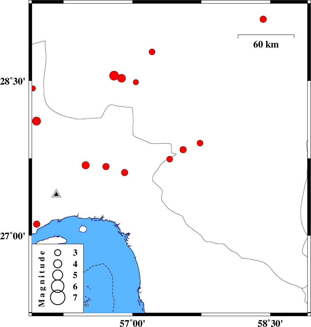
2019/02/21
|
12:21:38.1
|
15:51:38.1
| 27.743 | 57.405 | 14 |
ML2.9
|
Kerman Province, 38 km North of Manujan | |
|
|
2019/02/18
|
14:54:01.5
|
18:24:01.5
| 29.091 | 58.423 | 14 |
ML3.2
|
Kerman Province, 7 km of Bam | |
|
|
2019/02/16
|
05:34:23.8
|
09:04:23.8
| 28.426 | 55.916 | 14 |
ML2.7
|
Hormozgan Province, 13 km North of Hajiabad | |
|
|
2019/02/14
|
08:00:47.1
|
11:30:47.1
| 28.111 | 55.956 | 15 |
ML4.1
|
Hormozgan Province, 23 km South of Hajiabad | |
|
|
2019/02/06
|
01:41:38.0
|
05:11:38.0
| 27.684 | 56.49 | 14 |
ML3.7
|
Hormozgan Province, 59 km North-East of Bandar-e abbas | |
|
|
2019/02/05
|
20:53:01.9
|
00:23:01.9
| 28.778 | 57.213 | 15 |
ML2.9
|
Kerman Province, 53 km North-West of Jiroft | |
|
|
2019/02/03
|
12:48:46.0
|
16:18:46.0
| 27.898 | 57.735 | 18 |
ML2.9
|
Kerman Province, 7 km of Kahnuj | |
|
|
2019/01/29
|
00:24:00.5
|
03:54:00.5
| 27.671 | 56.711 | 14 |
ML3.3
|
Hormozgan Province, 59 km North-West of Dehbarez | |
|
|
2019/01/28
|
15:08:18.8
|
18:38:18.8
| 28.487 | 57.037 | 14 |
ML2.7
|
Kerman Province, 71 km South-West of Jiroft | |
|
|
2019/01/25
|
13:38:11.2
|
17:08:11.2
| 27.613 | 56.914 | 16 |
ML3.2
|
Hormozgan Province, 38 km North-West of Dehbarez | |
|
|
2019/01/25
|
01:32:21.4
|
05:02:21.4
| 27.112 | 55.957 | 15 |
ML3.2
|
Hormozgan Province, 33 km -West of Bandar-e abbas | |
|
|
2019/01/24
|
04:55:54.4
|
08:25:54.4
| 27.835 | 57.551 | 14 |
ML3.3
|
Kerman Province, 19 km South-West of Kahnuj | |
|
|
2019/01/22
|
23:50:26.0
|
03:20:26.0
| 28.55 | 56.8 | 7 |
Mb4.5
|
Kerman Province, 78 km South-East of Baft | |
|
|
2019/01/22
|
23:50:26.2
|
03:20:26.2
| 28.524 | 56.881 | 15 |
ML4
|
Kerman Province, 83 km South-East of Baft | |