Magnitude |
:3.7 |
| Date & Time (UTC) | 2025-02-14 01:09:31.9 |
| Date & Time (Local) | 1403/11/26 04:39:31.9 |
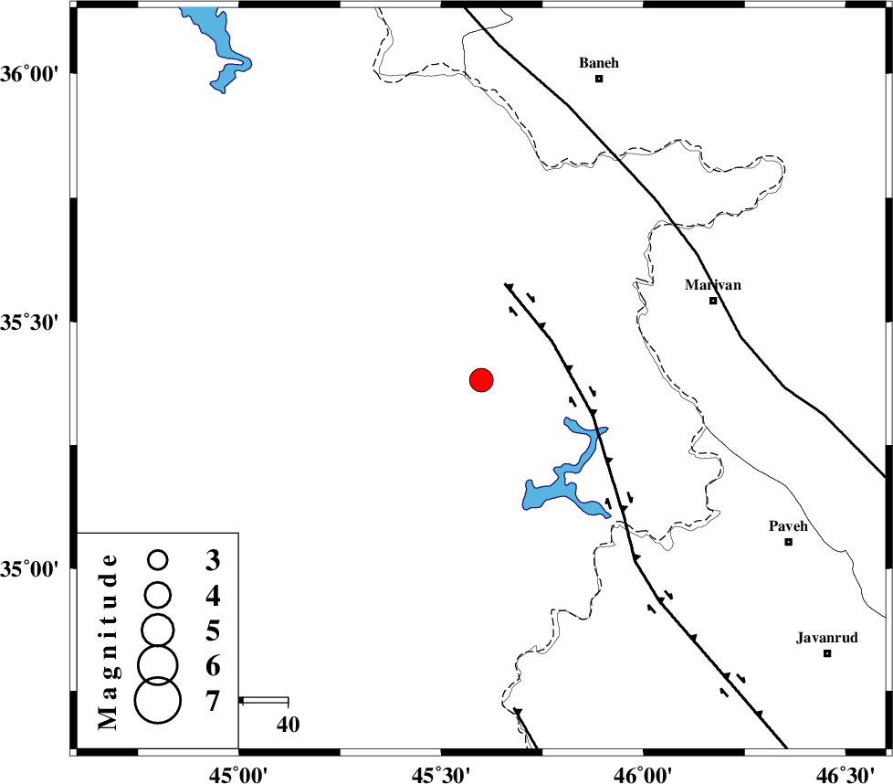
| Location | Lat:35.382 Lon: 45.599 |
| Region | Iraq, 25 km South-East of Sulaymaniyah |
Nearest Cities |
|
| 25 km South East of Sulaymaniyah, Iraq Province | |
| 46 km South West of Ney, Kurdistan Province | |
| 47 km North West of Markhil, Kermanshah Province | |
| 50 km South West of Bardeh rasheh, Kurdistan Province | |
| 54 km South West of Savoji, Kurdistan Province | |
| Depth | 10 km |
| Agency | |
Faults within 150 km: |
|
| HZF4 (Length: 492 km) , Distance to epicenter: 18 km | |
| PIRANSHAHR_F (Length: 253 km) , Distance to epicenter: 56 km | |
| MFF8 (Length: 48 km) , Distance to epicenter: 74 km | |
| Number of Phases | 8 |
| RMS | 0.1 |
| Number of Stations | 8 |
| Error in Latitude | >1.9 km |
| Error in Longitude | 1.9 km |
| Error in Depth | 5.4 km |
Download waveform in seisan format
to download seisan software Click here
to access information about IIEES stations Click here
Amplitude | ||||||||
| UID | Agency | Station | Component | Amplitude | Period | Arrival Time | Proccessing Time | Signal Clip |
| 197207 | IIEES SC | SRSL | Z | 10 | 1 | 2025-02-14 01:09:48 | 2025-02-15 07:19:00 | n |
| 197208 | IIEES SC | GURO | Z | 0.06 | 1 | 2025-02-14 01:10:38 | 2025-02-15 07:19:00 | n |
| 197209 | IIEES SC | GHVR | Z | 0.1 | 1 | 2025-02-14 01:10:45 | 2025-02-15 07:19:00 | n |
| 197210 | IIEES SC | NASN | Z | 0.02 | 1 | 2025-02-14 01:11:10 | 2025-02-15 07:19:00 | n |
Phase | ||||||||||||
| Agency | Station | Component | Phase Type | Phase Quality | First Motion | Observed Arrival Time | Time Residual | Loc. Flag | Input Weight | Distance | Azimuth | |
| IIEES SC | SRSL | Z | EPg | E | 2025-02-14 01:09:48 | 0 | y | 0 | 93 | 351 | ||
| IIEES SC | GURO | Z | EPn | E | 2025-02-14 01:10:38 | 0 | y | 0 | 474 | 318 | ||
| IIEES SC | GHVR | Z | EPn | E | 2025-02-14 01:10:45 | 0.2 | y | 0 | 526 | 101 | ||
| IIEES SC | GNI | Z | EPn | E | 2025-02-14 01:10:50 | 4.4 | n | 4 | 534 | 352 | ||
| IIEES SC | NASN | Z | EPn | E | 2025-02-14 01:11:10 | -0.2 | y | 0 | 724 | 113 | ||
| IIEES SC | GHIR | Z | EPn | E | 2025-02-14 01:11:50 | -0.9 | y | 0 | 1053 | 138 | ||
| IIEES SC | TABS | Z | EPn | E | 2025-02-14 01:11:44 | -9.7 | n | 4 | 1075 | 100 | ||
| IIEES SC | RAYN | Z | EPn | E | 2025-02-14 01:12:23 | 0.1 | y | 0 | 1315 | 180 | ||