Magnitude |
:3.4 |
| Date & Time (UTC) | 2025-04-13 00:17:38.4 |
| Date & Time (Local) | 1404/1/24 03:47:38.4 |
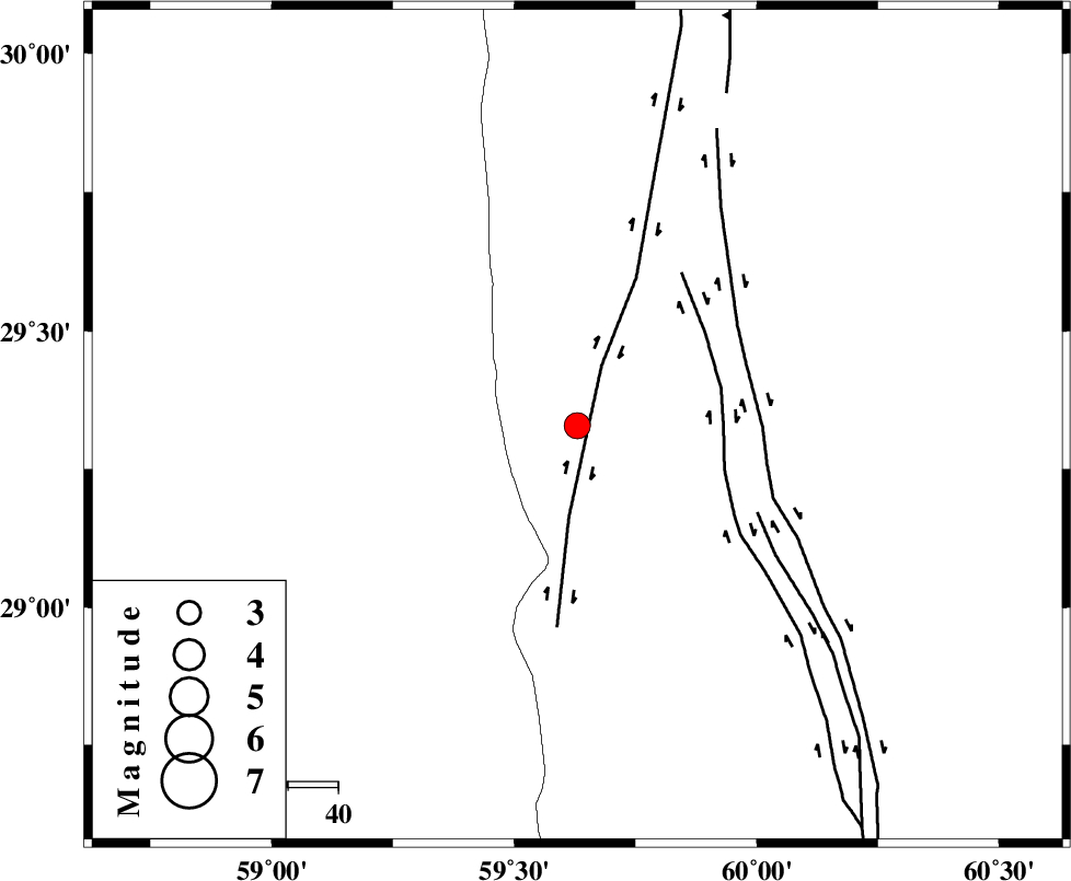
| Location | Lat:29.329 Lon: 59.63 |
| Region | Sistan va Baloochestan Province, 121 km South-West of Zahedan |
Nearest Cities |
|
| 48 km West of Hesaruyeh, Sistan va Baloochestan Province | |
| 66 km South West of Nosratabad, Sistan va Baloochestan Province | |
| 83 km North East of Fahroj, Kerman Province | |
| 88 km West of Mohamadabad, Sistan va Baloochestan Province | |
| 88 km North East of Void, Kerman Province | |
| Depth | 12 km |
| Agency | |
Faults within 150 km: |
|
| KANURAK_F (Length: 135 km) , Distance to epicenter: 13 km | |
| NOSRATABAD_F_Z1 (Length: 109 km) , Distance to epicenter: 29 km | |
| NOSRATABAD_F_Z3 (Length: 150 km) , Distance to epicenter: 36 km | |
| Number of Phases | 6 |
| RMS | 0.3 |
| Number of Stations | 6 |
| Error in Latitude | >5.4 km |
| Error in Longitude | 5.4 km |
| Error in Depth | 19.7 km |
Download waveform in seisan format
to download seisan software Click here
to access information about IIEES stations Click here
Amplitude | ||||||||
| UID | Agency | Station | Component | Amplitude | Period | Arrival Time | Proccessing Time | Signal Clip |
| 197864 | IIEES SC | KRBR | Z | 0.3 | 1 | 2025-04-13 00:18:22 | 2025-04-13 04:52:00 | n |
| 197865 | IIEES SC | KRBR | Z | 0.3 | 1 | 2025-04-13 00:18:54 | 2025-04-13 04:52:00 | n |
| 197866 | IIEES SC | CHBR | Z | 0.1 | 1 | 2025-04-13 00:18:38 | 2025-04-13 04:52:00 | n |
| 197867 | IIEES SC | TABS | Z | 0.03 | 1 | 2025-04-13 00:18:52 | 2025-04-13 04:52:00 | n |
Phase | ||||||||||||
| Agency | Station | Component | Phase Type | Phase Quality | First Motion | Observed Arrival Time | Time Residual | Loc. Flag | Input Weight | Distance | Azimuth | |
| IIEES SC | ZHSF | Z | EPg | E | 2025-04-13 00:17:57 | 0.2 | y | 0 | 115 | 74 | ||
| IIEES SC | KRBR | Z | EPn | E | 2025-04-13 00:18:22 | 0.7 | y | 0 | 287 | 285 | ||
| IIEES SC | KRBR | Z | ES | E | 2025-04-13 00:18:54 | 0 | y | 0 | 287 | 285 | ||
| IIEES SC | CHBR | Z | EPn | E | 2025-04-13 00:18:38 | -0.1 | y | 0 | 422 | 168 | ||
| IIEES SC | TABS | Z | EPn | E | 2025-04-13 00:18:52 | -0.4 | y | 0 | 535 | 334 | ||
| IIEES SC | YZKH | Z | EPn | E | 2025-04-13 00:19:09 | 9.6 | n | 4 | 589 | 305 | ||