Magnitude |
:2.9 |
| Date & Time (UTC) | 2025-04-15 10:28:06.7 |
| Date & Time (Local) | 1404/1/26 13:58:06.7 |
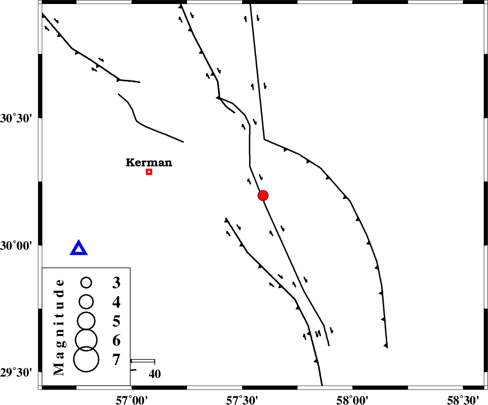
| Location | Lat:30.195 Lon: 57.594 |
| Region | Kerman Province, 51 km -East of Kerman |
Nearest Cities |
|
| 3 km of Sirch, Kerman Province | |
| 10 km North of Jushan, Kerman Province | |
| 27 km South West of Shahdad, Kerman Province | |
| 33 km North East of Mahan, Kerman Province | |
| 34 km North East of Langar, Kerman Province | |
| Depth | 12 km |
| Agency | |
Faults within 150 km: |
|
| GOLBAF_SIRCH_F (Length: 114 km) , Distance to epicenter: 4 km | |
| GOWK_F (Length: 152 km) , Distance to epicenter: 19 km | |
| SHAHDAD_F (Length: 108 km) , Distance to epicenter: 24 km | |
| Number of Phases | 5 |
| RMS | 0.2 |
| Number of Stations | 5 |
| Error in Latitude | >30.2 km |
| Error in Longitude | 57.6 km |
| Error in Depth | 12 km |
Download waveform in seisan format
to download seisan software Click here
to access information about IIEES stations Click here
Amplitude | ||||||||
| UID | Agency | Station | Component | Amplitude | Period | Arrival Time | Proccessing Time | Signal Clip |
| 197902 | IIEES SC | KRBR | Z | 1 | 1 | 2025-04-15 10:28:21 | 2025-04-16 05:56:00 | n |
| 197903 | IIEES SC | ZHSF | Z | 0.06 | 1 | 2025-04-15 10:28:53 | 2025-04-16 05:56:00 | n |
| 197904 | IIEES SC | TABS | Z | 0.03 | 1 | 2025-04-15 10:29:02 | 2025-04-16 05:56:00 | n |
Phase | ||||||||||||
| Agency | Station | Component | Phase Type | Phase Quality | First Motion | Observed Arrival Time | Time Residual | Loc. Flag | Input Weight | Distance | Azimuth | |
| IIEES SC | KRBR | Z | EPg | E | 2025-04-15 10:28:21 | 0 | y | 0 | 84 | 254 | ||
| IIEES SC | BSRN | Z | EPn | E | 2025-04-15 10:28:31 | -13.2 | n | 4 | 245 | 37 | ||
| IIEES SC | ZHSF | Z | EPn | E | 2025-04-15 10:28:53 | 0 | y | 0 | 313 | 102 | ||
| IIEES SC | YZKH | Z | EPn | E | 2025-04-15 10:29:01 | -0.3 | y | 0 | 375 | 310 | ||
| IIEES SC | TABS | Z | EPn | E | 2025-04-15 10:29:02 | 0.3 | y | 0 | 386 | 353 | ||