Magnitude |
:2.9 |
| Date & Time (UTC) | 2025-08-23 19:34:58.6 |
| Date & Time (Local) | 1404/6/1 23:04:58.6 |
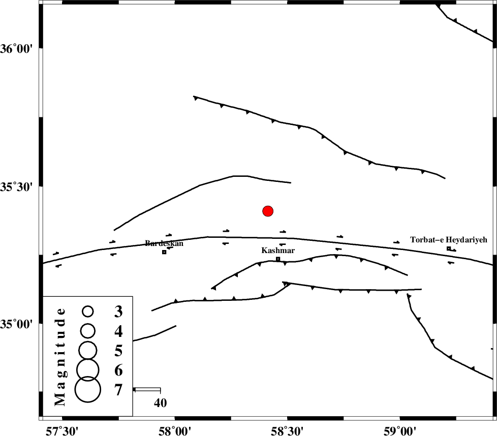
| Location | Lat:35.409 Lon: 58.413 |
| Region | Khorasan(center) Province, 20 km North of Kashmar |
Nearest Cities |
|
| 7 km of Toroq, Khorasan(center) Province | |
| 7 km of Rivash, Khorasan(center) Province | |
| 17 km North of Kasrineh, Khorasan(center) Province | |
| 19 km North East of Khalilabad, Khorasan(center) Province | |
| 20 km North of Kashmar, Khorasan(center) Province | |
| Depth | 12 km |
| Agency | |
Faults within 150 km: |
|
| BIJVARD_F (Length: 83 km) , Distance to epicenter: 13 km | |
| DORUNEH_F (Length: 713 km) , Distance to epicenter: 15 km | |
| KASHMAR_F (Length: 91 km) , Distance to epicenter: 20 km | |
| Number of Phases | 9 |
| RMS | 0.6 |
| Number of Stations | 9 |
| Error in Latitude | >6.9 km |
| Error in Longitude | 6.9 km |
| Error in Depth | 999 km |
Download waveform in seisan format
to download seisan software Click here
to access information about IIEES stations Click here
Amplitude | ||||||||
| UID | Agency | Station | Component | Amplitude | Period | Arrival Time | Proccessing Time | Signal Clip |
| 198906 | IIEES SC | TABS | Z | 0.2 | 1 | 2025-08-23 19:35:34 | 2025-08-25 08:52:00 | n |
| 198907 | IIEES SC | SHRT | Z | 0.3 | 1 | 2025-08-23 19:35:39 | 2025-08-25 08:52:00 | n |
| 198908 | IIEES SC | ABGH | Z | 0.01 | 1 | 2025-08-23 19:35:51 | 2025-08-25 08:52:00 | n |
Phase | ||||||||||||
| Agency | Station | Component | Phase Type | Phase Quality | First Motion | Observed Arrival Time | Time Residual | Loc. Flag | Input Weight | Distance | Azimuth | |
| IIEES SC | KAGH | Z | EPn | E | 2025-08-23 19:35:33 | -0.5 | y | 0 | 219 | 39 | ||
| IIEES SC | SHRO | Z | EPn | E | 2025-08-23 19:35:19 | -15.7 | n | 4 | 227 | 287 | ||
| IIEES SC | TABS | Z | EPn | E | 2025-08-23 19:35:34 | -0.6 | y | 0 | 229 | 211 | ||
| IIEES SC | SHRT | Z | EPn | E | 2025-08-23 19:35:39 | 0.6 | y | 0 | 261 | 139 | ||
| IIEES SC | BJRD | Z | EPn | E | 2025-08-23 19:35:40 | 0.2 | y | 0 | 270 | 341 | ||
| IIEES SC | ABGH | Z | EPn | E | 2025-08-23 19:35:51 | 0.9 | y | 0 | 357 | 294 | ||
| IIEES SC | BSRN | Z | EPn | E | 2025-08-23 19:35:49 | -5.2 | n | 4 | 388 | 170 | ||
| IIEES SC | YZKH | Z | EPn | E | 2025-08-23 19:35:38 | -29.2 | n | 4 | 487 | 227 | ||
| IIEES SC | KRBR | Z | EPn | E | 2025-08-23 19:36:37 | 13.6 | n | 4 | 622 | 194 | ||