Magnitude |
:3 |
| Date & Time (UTC) | 2022-10-21 05:11:21.3 |
| Date & Time (Local) | 1401/7/29 08:41:21.3 |
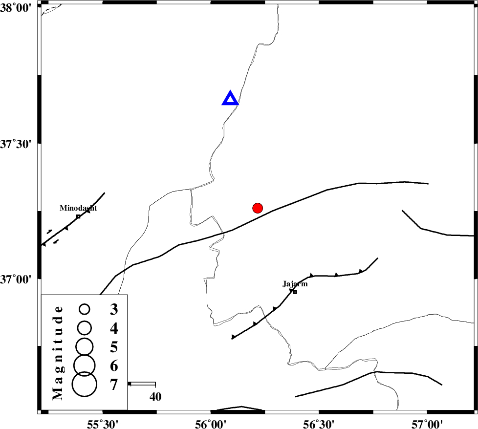
| Location | Lat:37.261 Lon: 56.216 |
| Region | Khorasan(north) Province, 38 km North-West of Jajarm |
Nearest Cities |
|
| 31 km North of Garmeh, Khorasan(north) Province | |
| 38 km North West of Jajarm, Khorasan(north) Province | |
| 46 km North East of Nardin, Semnan Province | |
| 49 km South East of Golidagh, Golestan Province | |
| 49 km North East of Rezvan, Semnan Province | |
| Depth | 12 km |
| Agency | |
Faults within 150 km: |
|
| ROBATE_QARABIL_F (Length: 168 km) , Distance to epicenter: 6 km | |
| JAJARAM_F (Length: 77 km) , Distance to epicenter: 35 km | |
| ESFARAYEN_F (Length: 111 km) , Distance to epicenter: 59 km | |
| Number of Phases | 10 |
| RMS | 0.3 |
| Number of Stations | 10 |
| Error in Latitude | >3.3 km |
| Error in Longitude | 3.3 km |
| Error in Depth | 7 km |
Download waveform in seisan format
to download seisan software Click here
to access information about IIEES stations Click here
Amplitude | ||||||||
| UID | Agency | Station | Component | Amplitude | Period | Arrival Time | Proccessing Time | Signal Clip |
| 174368 | IIEES SC | BJRD | Z | 0.5 | 1 | 2022-10-21 05:11:41 | 2022-10-22 06:36:00 | n |
| 174369 | IIEES SC | KAGH | Z | 0.03 | 1 | 2022-10-21 05:12:10 | 2022-10-22 06:36:00 | n |
| 174370 | IIEES SC | TBJM | Z | 0.06 | 1 | 2022-10-21 05:12:22 | 2022-10-22 06:36:00 | n |
Phase | ||||||||||||
| Agency | Station | Component | Phase Type | Phase Quality | First Motion | Observed Arrival Time | Time Residual | Loc. Flag | Input Weight | Distance | Azimuth | |
| IIEES SC | MRVT | Z | EPg | E | 2022-10-21 05:11:29 | -0.2 | y | 0 | 46 | 346 | ||
| IIEES SC | BJRD | Z | EPg | E | 2022-10-21 05:11:41 | 0.2 | y | 0 | 116 | 65 | ||
| IIEES SC | ABGH | Z | EPg | E | 2022-10-21 05:11:44 | 0.3 | y | 0 | 139 | 245 | ||
| IIEES SC | QUCH | Z | EPn | E | 2022-10-21 05:11:54 | 0.5 | y | 0 | 202 | 97 | ||
| IIEES SC | GLO | Z | EPn | E | 2022-10-21 05:11:57 | -0.2 | y | 0 | 229 | 248 | ||
| IIEES SC | KAGH | Z | EPn | E | 2022-10-21 05:12:10 | -0.4 | y | 0 | 335 | 96 | ||
| IIEES SC | JRKH | Z | EPn | E | 2022-10-21 05:12:18 | -0.1 | y | 0 | 399 | 112 | ||
| IIEES SC | TABS | Z | EPn | E | 2022-10-21 05:12:28 | 8 | n | 4 | 409 | 168 | ||
| IIEES SC | KKHK | Z | EPn | E | 2022-10-21 05:12:27 | 7 | n | 4 | 410 | 148 | ||
| IIEES SC | TBJM | Z | EPn | E | 2022-10-21 05:12:22 | -0.5 | y | 0 | 431 | 121 | ||