Magnitude |
:3.6 |
| Date & Time (UTC) | 2025-02-14 11:42:29.3 |
| Date & Time (Local) | 1403/11/26 15:12:29.3 |
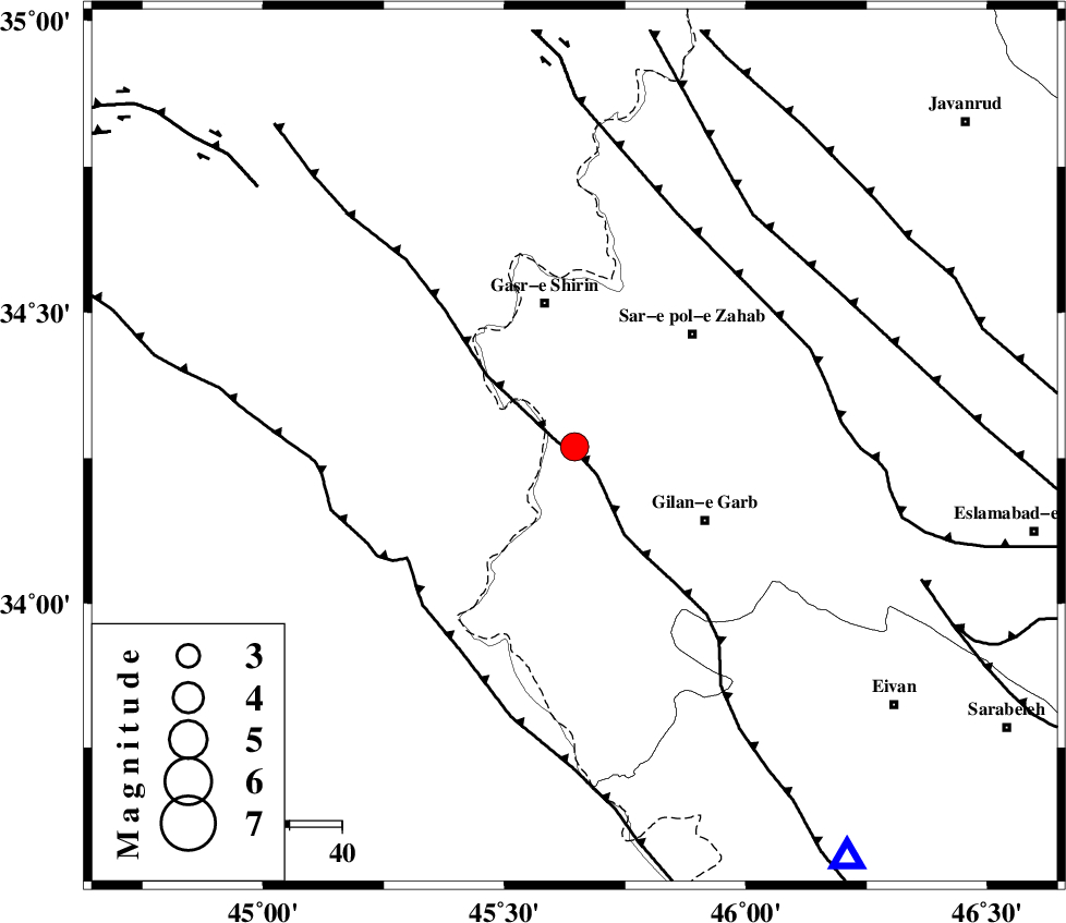
| Location | Lat:34.269 Lon: 45.645 |
| Region | Kermanshah Province, 28 km South of Qasr-E-Shirin |
Nearest Cities |
|
| 20 km South of Seyyed sohrab, Kermanshah Province | |
| 20 km West of Chub baghan, Kermanshah Province | |
| 21 km South East of Khosravi, Kermanshah Province | |
| 27 km South West of Qareh belagh, Kermanshah Province | |
| 28 km South of Qasr-E-Shirin, Kermanshah Province | |
| Depth | 12 km |
| Agency | |
Faults within 150 km: |
|
| MFF8 (Length: 48 km) , Distance to epicenter: 32 km | |
| ZFF4 (Length: 128 km) , Distance to epicenter: 40 km | |
| MFF7 (Length: 99 km) , Distance to epicenter: 46 km | |
| Number of Phases | 9 |
| RMS | 0.5 |
| Number of Stations | 9 |
| Error in Latitude | >2.8 km |
| Error in Longitude | 2.8 km |
| Error in Depth | 11.4 km |
Download waveform in seisan format
to download seisan software Click here
to access information about IIEES stations Click here
Amplitude | ||||||||
| UID | Agency | Station | Component | Amplitude | Period | Arrival Time | Proccessing Time | Signal Clip |
| 197167 | IIEES SC | SRSL | Z | 1 | 1 | 2025-02-14 11:43:05 | 2025-02-15 09:27:00 | n |
| 197168 | IIEES SC | SRSL | Z | 1 | 1 | 2025-02-14 11:43:29 | 2025-02-15 09:27:00 | n |
| 197169 | IIEES SC | GURO | Z | 0.06 | 1 | 2025-02-14 11:43:49 | 2025-02-15 09:27:00 | n |
| 197170 | IIEES SC | NASN | Z | 0.02 | 1 | 2025-02-14 11:44:02 | 2025-02-15 09:27:00 | n |
Phase | ||||||||||||
| Agency | Station | Component | Phase Type | Phase Quality | First Motion | Observed Arrival Time | Time Residual | Loc. Flag | Input Weight | Distance | Azimuth | |
| IIEES SC | SRSL | Z | EPn | E | 2025-02-14 11:43:05 | 0.9 | y | 0 | 216 | 355 | ||
| IIEES SC | SRSL | Z | ES | E | 2025-02-14 11:43:29 | -0.2 | y | 0 | 216 | 355 | ||
| IIEES SC | ASAO | Z | EPn | E | 2025-02-14 11:43:27 | -0.3 | y | 0 | 404 | 86 | ||
| IIEES SC | DHK1 | Z | EPn | E | 2025-02-14 11:43:40 | -0.2 | y | 0 | 513 | 211 | ||
| IIEES SC | GHVR | Z | EPn | E | 2025-02-14 11:43:56 | 14.7 | n | 4 | 516 | 87 | ||
| IIEES SC | GURO | Z | EPn | E | 2025-02-14 11:43:49 | 0.6 | y | 0 | 575 | 326 | ||
| IIEES SC | DAMV | Z | EPn | E | 2025-02-14 11:43:50 | -0.9 | y | 0 | 597 | 75 | ||
| IIEES SC | NASN | Z | EPn | E | 2025-02-14 11:44:02 | 0.1 | y | 0 | 685 | 104 | ||
| IIEES SC | GHIR | Z | EPn | E | 2025-02-14 11:44:37 | 0.6 | y | 0 | 964 | 133 | ||