Magnitude |
:2.9 |
| Date & Time (UTC) | 2025-05-03 07:35:56.5 |
| Date & Time (Local) | 1404/2/13 11:05:56.5 |
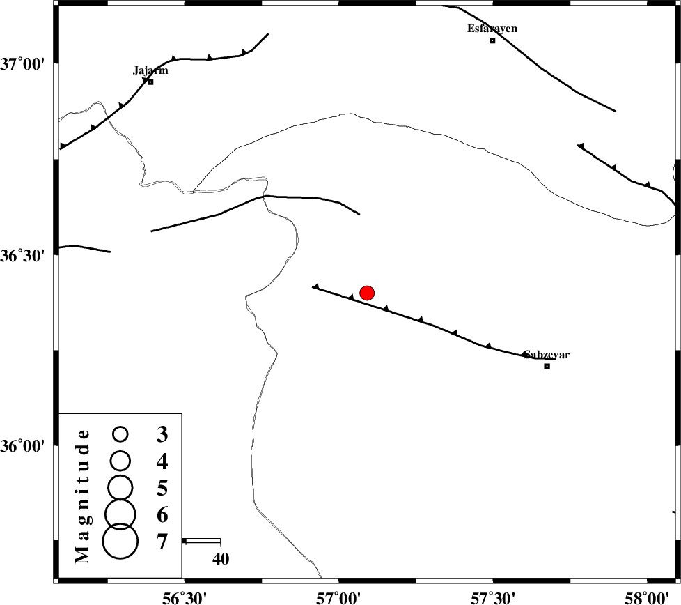
| Location | Lat:36.4 Lon: 57.091 |
| Region | Khorasan(center) Province, 56 km North-West of Sabzevar |
Nearest Cities |
|
| 10 km North of Sadkharu, Khorasan(center) Province | |
| 20 km North East of Davarzan, Khorasan(center) Province | |
| 23 km South of Abuchenari, Khorasan(center) Province | |
| 26 km South of Jogtay, Khorasan(center) Province | |
| 29 km North West of Rivand, Khorasan(center) Province | |
| Depth | 12 km |
| Agency | |
Faults within 150 km: |
|
| SABZEVAR_F (Length: 81 km) , Distance to epicenter: 16 km | |
| JOGHATAI_F (Length: 70 km) , Distance to epicenter: 23 km | |
| RIVAND_F (Length: 70 km) , Distance to epicenter: 75 km | |
| Number of Phases | 6 |
| RMS | 0.1 |
| Number of Stations | 6 |
| Error in Latitude | >1.6 km |
| Error in Longitude | 1.6 km |
| Error in Depth | 10.6 km |
Download waveform in seisan format
to download seisan software Click here
to access information about IIEES stations Click here
Amplitude | ||||||||
| UID | Agency | Station | Component | Amplitude | Period | Arrival Time | Proccessing Time | Signal Clip |
| 198075 | IIEES SC | SHRO | Z | 0.5 | 1 | 2025-05-03 07:36:14 | 2025-05-04 04:22:00 | n |
| 198076 | IIEES SC | MRVT | Z | 0.4 | 1 | 2025-05-03 07:36:23 | 2025-05-04 04:22:00 | n |
| 198077 | IIEES SC | TABS | Z | 0.05 | 1 | 2025-05-03 07:36:42 | 2025-05-04 04:22:00 | n |
| 198078 | IIEES SC | NASN | Z | 0.02 | 1 | 2025-05-03 07:37:14 | 2025-05-04 04:22:00 | n |
Phase | ||||||||||||
| Agency | Station | Component | Phase Type | Phase Quality | First Motion | Observed Arrival Time | Time Residual | Loc. Flag | Input Weight | Distance | Azimuth | |
| IIEES SC | SHRO | Z | EPg | E | 2025-05-03 07:36:14 | -0.5 | y | 0 | 106 | 246 | ||
| IIEES SC | MRVT | Z | EPg | E | 2025-05-03 07:36:23 | 0 | y | 0 | 166 | 327 | ||
| IIEES SC | KAGH | Z | EPn | E | 2025-05-03 07:36:37 | -0.1 | y | 0 | 263 | 77 | ||
| IIEES SC | TABS | Z | EPn | E | 2025-05-03 07:36:42 | 0.1 | y | 0 | 305 | 180 | ||
| IIEES SC | YZKH | Z | EPn | E | 2025-05-03 07:37:06 | 0 | y | 0 | 501 | 207 | ||
| IIEES SC | NASN | Z | EPn | E | 2025-05-03 07:37:14 | 0.2 | y | 0 | 560 | 225 | ||