Magnitude |
:3 |
| Date & Time (UTC) | 2025-07-31 21:25:11.7 |
| Date & Time (Local) | 1404/5/10 00:55:11.7 |
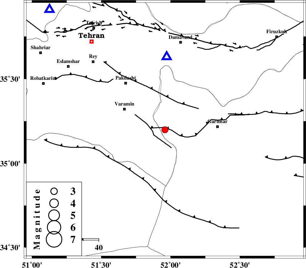
| Location | Lat:35.199 Lon: 51.959 |
| Region | Semnan Province, 35 km -West of Garmsar |
Nearest Cities |
|
| 11 km of Cheshmeh nadi, Semnan Province | |
| 11 km of Shorqazi, Semnan Province | |
| 18 km South West of Evanekay, Semnan Province | |
| 24 km South East of Pishva, Tehran Province | |
| 25 km South East of Khalilabad, Tehran Province | |
| Depth | 12 km |
| Agency | |
Faults within 150 km: |
|
| GARMSAR_F (Length: 77 km) , Distance to epicenter: 2 km | |
| PISHAV_F (Length: 34 km) , Distance to epicenter: 8 km | |
| EYVANEKEY_F (Length: 74 km) , Distance to epicenter: 20 km | |
| Number of Phases | 8 |
| RMS | 0.7 |
| Number of Stations | 8 |
| Error in Latitude | >35.2 km |
| Error in Longitude | 52 km |
| Error in Depth | 12 km |
Download waveform in seisan format
to download seisan software Click here
to access information about IIEES stations Click here
Amplitude | ||||||||
| UID | Agency | Station | Component | Amplitude | Period | Arrival Time | Proccessing Time | Signal Clip |
| 198934 | IIEES SC | GHVR | Z | 0.8 | 1 | 2025-07-31 21:25:28 | 2025-08-27 05:25:00 | n |
| 198935 | IIEES SC | NASN | Z | 0.1 | 1 | 2025-07-31 21:25:55 | 2025-08-27 05:25:00 | n |
| 198936 | IIEES SC | ABGH | Z | 0.2 | 1 | 2025-07-31 21:25:58 | 2025-08-27 05:25:00 | n |
| 198937 | IIEES SC | TABS | Z | 0.01 | 1 | 2025-07-31 21:26:21 | 2025-08-27 05:25:00 | n |
Phase | ||||||||||||
| Agency | Station | Component | Phase Type | Phase Quality | First Motion | Observed Arrival Time | Time Residual | Loc. Flag | Input Weight | Distance | Azimuth | |
| IIEES SC | DAMV | Z | EPg | E | 2025-07-31 21:24:52 | -28 | n | 4 | 48 | 1 | ||
| IIEES SC | GHVR | Z | EPg | E | 2025-07-31 21:25:28 | -0.4 | y | 0 | 103 | 219 | ||
| IIEES SC | NASN | Z | EPn | E | 2025-07-31 21:25:55 | 1 | y | 0 | 278 | 164 | ||
| IIEES SC | ABGH | Z | EPn | E | 2025-07-31 21:25:58 | 0.1 | y | 0 | 308 | 56 | ||
| IIEES SC | SHRO | Z | EPn | E | 2025-07-31 21:25:59 | -7.7 | n | 4 | 378 | 76 | ||
| IIEES SC | YZKH | Z | EPn | E | 2025-07-31 21:25:47 | -21.6 | n | 4 | 396 | 142 | ||
| IIEES SC | TABS | Z | EPn | E | 2025-07-31 21:26:21 | -0.8 | y | 0 | 505 | 110 | ||
| IIEES SC | BJRD | Z | EPn | E | 2025-07-31 21:25:45 | -44.3 | n | 4 | 562 | 60 | ||