Magnitude |
:3.4 |
| Date & Time (UTC) | 2014-09-05 08:36:09.8 |
| Date & Time (Local) | 1393/6/14 13:06:09.8 |
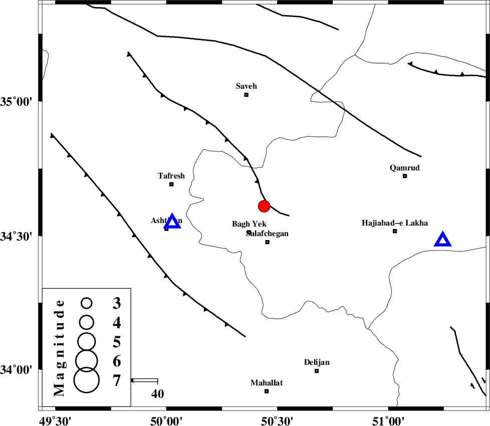
| Location | Lat:34.61 Lon: 50.44 |
| Region | Qom Province, 40 km West of Qom |
Nearest Cities |
|
| 12 km North of Bagh yek, Qom Province | |
| 15 km North of Salafchegan, Qom Province | |
| 19 km North East of Dastjerd, Qom Province | |
| 20 km South of Gazran, Qom Province | |
| 33 km South of Qareh chay, Markazi Province | |
| Depth | 15 km |
| Agency | |
Faults within 150 km: |
|
| INDES_F (Length: 98 km) , Distance to epicenter: 2 km | |
| TAFRESH_F (Length: 117 km) , Distance to epicenter: 49 km | |
| KUSHK_E_NOSRAT_F (Length: 230 km) , Distance to epicenter: 53 km | |
| Number of Phases | 8 |
| RMS | 0.3 |
| Number of Stations | 5 |
| Error in Latitude | >3.1 km |
| Error in Longitude | 2.3 km |
| Error in Depth | 6.8 km |
Download waveform in seisan format
to download seisan software Click here
to access information about IIEES stations Click here
Amplitude | ||||||||
| UID | Agency | Station | Component | Amplitude | Period | Arrival Time | Proccessing Time | Signal Clip |
| 93504 | IIEES | GHVR | E | 1305.7 | 0.27 | 2014-09-05 08:36:34 | 2014-09-06 10:17:00 | n |
| 93505 | IIEES | CHTH | N | 808.1 | 0.22 | 2014-09-05 08:36:58 | 2014-09-06 10:17:00 | n |
Phase | ||||||||||||
| Agency | Station | Component | Phase Type | Phase Quality | First Motion | Observed Arrival Time | Time Residual | Loc. Flag | Input Weight | Distance | Azimuth | |
| IIEES | ASAO | Z | Pg | E | 2014-09-05 08:36:17 | -0.12 | y | 38.4 | 259 | |||
| IIEES | ASAO | N | Sg | E | 2014-09-05 08:36:22 | 0.1 | y | 38.4 | 259 | |||
| IIEES | GHVR | Z | Pg | E | 2014-09-05 08:36:22 | -0.18 | y | 75.7 | 101 | |||
| IIEES | GHVR | N | Sg | E | 2014-09-05 08:36:32 | 0.38 | y | 75.7 | 101 | |||
| IIEES | CHTH | Z | Pg | E | 2014-09-05 08:36:35 | -0.55 | y | 157 | 23 | |||
| IIEES | CHTH | N | Sg | E | 2014-09-05 08:36:55 | 0.34 | y | 157 | 23 | |||
| IIEES | SNGE | Z | Pn | E | 2014-09-05 08:36:53 | 0.31 | y | 287 | 282 | |||
| IIEES | TABS | Z | Pn | E | 2014-09-05 08:37:34 | -0.5 | y | 625 | 98 | |||